
檔案:Borneo Topography.png

Yi-lám thai séu: 567 × 600 chhiong-su. Khì-thâ kié-sak-thu: 227 × 240 chhiong-su | 454 × 480 chhiong-su | 726 × 768 chhiong-su | 968 × 1,024 chhiong-su | 1,725 × 1,824 chhiong-su.
Ngièn-pún tóng-on (1,725 × 1,824 chhiong-su, vùn-khien thai-séu: 2.52 MB, MIME lui-hîn: image/png)
Vùn-khien sot-mìn
| Mèu-sut |
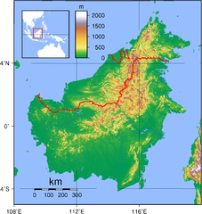
English: Relief (hypsometric) map of Borneo. Red lines represent national borders between Indonesia (south), Malaysia (north), and Brunei (top north). Created with GMT from publicly released GLOBE data[1]. For locator version, see File:Borneo Locator Topography.png.
Français : Carte du relief de l'île de Borneo. Les lignes rouges représentent les frontières séparant les états se partageant l'île de Bornéo : L'Indonésie (au sud), la Malaisie (au nord de l'Indonésie) et l'état de Bruneï (au nord de la Malaisie). Image produite à l'aide de la suite logicielle GMT à partir des données publiques GLOBE. Une version locator est disponible. |
| Ngit-khì | |
| Lòi-ngièn | Chhṳ-kâ ke chok-phín |
| Chok-chá | Sadalmelik |

|
根據最有價值圖像標準,這張圖像被評定为在Hypsometric map of Borneo範疇內最有價值的共享資源圖像。你可以在Commons:Valued image candidates/Borneo Topography.png参看它的提名。 |
Su-khièn
| 我,此作品的版權所有人,釋出此作品至公共領域。此授權條款在全世界均適用。 這可能在某些國家不合法,如果是的話: 我授予任何人有權利使用此作品於任何用途,除受法律約束外,不受任何限制。 |
Vùn-khien li̍t-sṳ́
Tiám-khim ngit-khì / sṳ̀-kiên lòi chhà-khon tông-sṳ̀ chhut-hien-ko ke vùn-khien.
| Ngit khì / Sṳ̀-kiên | Suk-lio̍k-thù | Vì-thu | Yung-fu | Yi-kien | |
|---|---|---|---|---|---|
| tông-chhièn | 2007年9月1日 (Liuk) 19:17 | | 1,725 × 1,824(2.52 MB) | Sadalmelik | Better data, better colours |
| 2007年6月3日 (Ngit) 20:54 |  | 2,083 × 2,158(1.67 MB) | Sadalmelik | {{Information |Description=Topographical map of Borneo. Created with GMT from publicly released GLOBE data[http://www.ngdc.noaa.gov/mgg/topo/globe.html]. |Source=self-made |Date=June 3, 2007 |Author= User:Sadalmelik }} Category:Maps of Malaysia |
Vùn-khien yung-chhú
Hâ poi ke 1-chak ya̍p-mien lièn-chiap to pún vùn-khien:
Chhiòn-vet tóng-on sṳ́-yung chhong-khóng
Hâ-lie̍t khì-thâ Wiki chûng sṳ́-yung liá-chak tóng on:
- af.wikipedia.org ke sṳ́-yung chhong-khóng
- ar.wikipedia.org ke sṳ́-yung chhong-khóng
- az.wikipedia.org ke sṳ́-yung chhong-khóng
- ban.wikipedia.org ke sṳ́-yung chhong-khóng
- be-tarask.wikipedia.org ke sṳ́-yung chhong-khóng
- be.wikipedia.org ke sṳ́-yung chhong-khóng
- bg.wikipedia.org ke sṳ́-yung chhong-khóng
- bn.wikipedia.org ke sṳ́-yung chhong-khóng
- ca.wikipedia.org ke sṳ́-yung chhong-khóng
- ceb.wikipedia.org ke sṳ́-yung chhong-khóng
- de.wikipedia.org ke sṳ́-yung chhong-khóng
- de.wikivoyage.org ke sṳ́-yung chhong-khóng
- de.wiktionary.org ke sṳ́-yung chhong-khóng
- el.wikipedia.org ke sṳ́-yung chhong-khóng
- el.wiktionary.org ke sṳ́-yung chhong-khóng
- en.wikipedia.org ke sṳ́-yung chhong-khóng
- Borneo
- East Malaysia
- Talk:Borneo
- List of endemic birds of Borneo
- Outline of Malaysia
- User:Chickstarr404/Gather lists/13386 – "A Travelers Alphabet" by Stephen Runciman
- Wikipedia:Today's featured list/June 2021
- Wikipedia:Today's featured list/June 11, 2021
- Wikipedia:Main Page history/2021 June 11
- Wikipedia:Main Page history/2021 June 11b
- Phalaenopsis kapuasensis
- Phalaenopsis luteola
- Phalaenopsis modesta
- Phalaenopsis pantherina
- Phalaenopsis × singuliflora
- User:AryKun/Misc
- Naval Base Borneo
- User:Asang Lawai
- Template:User Dayak
- en.wikibooks.org ke sṳ́-yung chhong-khóng
- en.wikinews.org ke sṳ́-yung chhong-khóng
- eo.wikipedia.org ke sṳ́-yung chhong-khóng
- es.wikipedia.org ke sṳ́-yung chhong-khóng
- et.wikipedia.org ke sṳ́-yung chhong-khóng
- eu.wikipedia.org ke sṳ́-yung chhong-khóng
- fa.wikipedia.org ke sṳ́-yung chhong-khóng
- fi.wikipedia.org ke sṳ́-yung chhong-khóng
- fo.wikipedia.org ke sṳ́-yung chhong-khóng
- frr.wikipedia.org ke sṳ́-yung chhong-khóng
- fr.wikipedia.org ke sṳ́-yung chhong-khóng
Kiám-sṳ liá vùn-khien ke kiên-tô chhiòn-vet sṳ́-yung chhong-khóng.