
檔案:Départements et régions de France.svg

此 SVG 檔案的 PNG 預覽的大小:588 × 550 chhiong-su。 Khì-thâ kié-sak-thu: 257 × 240 chhiong-su | 513 × 480 chhiong-su | 821 × 768 chhiong-su | 1,095 × 1,024 chhiong-su | 2,190 × 2,048 chhiong-su.
Ngièn-pún tóng-on (SVG文件,尺寸:588×550像素,文件大細:362 KB)
Vùn-khien sot-mìn
| Mèu-sut |
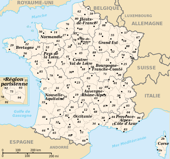
 English: Departements and region of France. French geographics objects use ISO 3166-2:FR for ids.
Español: Mapa de los departamentos franceses.
Français : Départements et régions de France avec leurs préfectures. Les objects géographiques français utilisent les identifiants provenant de ISO 3166-2:FR |
||
| Ngit-khì | |||
| Lòi-ngièn | Chhṳ-kâ ke chok-phín | ||
| Chok-chá | bayo | ||
| Khièn-han: (Chhùng-yung liá-chak tóng-on) |
|
||
| 其他版本 |
[]
|
![(français) Départements (numérotés) et régions de France avant 01/01/2016 (nommées, non colorisés) [source of all the following derivatives]](http://commons.wikimedia.org/wiki/File:D%C3%A9partements_et_r%C3%A9gions_de_France.svg)


![(français) Départements (numérotés) et régions de France avant 01/01/2016 (non nommées, non colorisées) [rendu amélioré] (version utilisée pour rendre la carte clicable par département)](http://commons.wikimedia.org/wiki/File:D%C3%A9partements_et_r%C3%A9gions_de_France_-_Noname-2016.svg)


![(français) Départements (numérotés) et régions de France avant 01/01/2016 (nommées et colorisées) [regions named/colored]](http://commons.wikimedia.org/wiki/File:D%C3%A9partements%2Br%C3%A9gions_(France).svg)
![(français) Départements (numérotés) et régions de France avant 01/01/2016 (nommées et colorisées) [15% magnified, rapid JPEG format 5x faster]](http://commons.wikimedia.org/wiki/File:France_departements_regions_narrow.jpg)
![(français) Départements de France (numérotés, non colorisés)[numeric labels, uncolorized]](http://commons.wikimedia.org/wiki/File:D%C3%A9partements_de_France.svg)


![(multilingue) Départements de France (sans aucun libellé) [No labels]](http://commons.wikimedia.org/wiki/File:D%C3%A9partements_et_r%C3%A9gions_de_France_vide.svg)
Vùn-khien li̍t-sṳ́
Tiám-khim ngit-khì / sṳ̀-kiên lòi chhà-khon tông-sṳ̀ chhut-hien-ko ke vùn-khien.
| Ngit khì / Sṳ̀-kiên | Suk-lio̍k-thù | Vì-thu | Yung-fu | Yi-kien | |
|---|---|---|---|---|---|
| tông-chhièn | 2024年4月26日 (Ńg) 11:50 | | 588 × 550(362 KB) | Jack ma | - correction of region limits (closing of Grand Est and Nouvelle-Aquitaine) |
| 2024年4月12日 (Ńg) 09:02 |  | 588 × 550(438 KB) | Jack ma | Updated French administrative regions of 2016 | |
| 2014年7月22日 (Ngi) 16:18 |  | 588 × 550(466 KB) | Seudo | Fixed orthograph mistake ("région parisenne") and added hyphens in Pays-de-la-Loire | |
| 2009年5月16日 (Liuk) 02:55 |  | 588 × 550(466 KB) | Archimatth | Une seule préfecture varoise | |
| 2008年6月20日 (Ńg) 07:26 |  | 588 × 550(467 KB) | Bayo | patch region/departement id with ISO 3166-2:FR | |
| 2008年6月17日 (Ngi) 09:02 |  | 588 × 550(474 KB) | Bayo | {{Information |Description= |Source= |Date= |Author= |Permission= |other_versions= }} | |
| 2008年5月10日 (Liuk) 16:56 |  | 588 × 550(459 KB) | Bayo | region name bigger, patch typo of some names | |
| 2006年5月22日 (Yit) 20:34 |  | 588 × 550(459 KB) | Bayo | patch : typo | |
| 2006年4月17日 (Yit) 15:11 |  | 588 × 550(459 KB) | Bayo | ajout de l'échelle | |
| 2006年4月17日 (Yit) 14:45 |  | 588 × 550(455 KB) | Bayo | *'''description''' : Départements et régions et de France avec leurs préfectures. *'''auteur''' : bayo Category:Maps of departements of France Category:Maps of régions of France == Licensing == {{PD-self}} |
Vùn-khien yung-chhú
Mò ya̍p-mien lièn-chiap to pún vùn-khien.
Chhiòn-vet tóng-on sṳ́-yung chhong-khóng
Hâ-lie̍t khì-thâ Wiki chûng sṳ́-yung liá-chak tóng on:
- af.wikipedia.org ke sṳ́-yung chhong-khóng
- ceb.wikipedia.org ke sṳ́-yung chhong-khóng
- da.wikipedia.org ke sṳ́-yung chhong-khóng
- es.wikipedia.org ke sṳ́-yung chhong-khóng
- eu.wikipedia.org ke sṳ́-yung chhong-khóng
- fi.wikipedia.org ke sṳ́-yung chhong-khóng
- fr.wikipedia.org ke sṳ́-yung chhong-khóng
- Aménagement du territoire en France
- Discussion modèle:Fragéoloc
- Wikipédia:Atelier graphique/Images à améliorer/Archives/Novembre 2006
- Wikipédia:Atelier graphique/Images à améliorer/Archives/Mai 2007
- Discussion utilisateur:Mirondia
- Utilisateur:Wikisoft*/Tests cartes
- Discussion utilisateur:Sting/Archive 08
- Patrimoine juif d'Alsace
- Patrimoine juif de Lorraine
- Patrimoine juif du Sud-Est de la France et de la principauté de Monaco
- Patrimoine juif d'Île-de-France
- Patrimoine juif du Sud-Ouest de la France
- Patrimoine juif des régions du centre, partie ouest
- Patrimoine juif du Nord et de l'Est de la France (sauf Alsace et Lorraine)
- Patrimoine protestant de Lorraine
- ia.wikipedia.org ke sṳ́-yung chhong-khóng
- la.wikipedia.org ke sṳ́-yung chhong-khóng
- lt.wikipedia.org ke sṳ́-yung chhong-khóng
- oc.wikipedia.org ke sṳ́-yung chhong-khóng
- pt.wikipedia.org ke sṳ́-yung chhong-khóng
- qu.wikipedia.org ke sṳ́-yung chhong-khóng
- se.wikipedia.org ke sṳ́-yung chhong-khóng
- vi.wikipedia.org ke sṳ́-yung chhong-khóng