
檔案:Mongols-map.png
Yi-lám thai séu: 722 × 599 chhiong-su. Khì-thâ kié-sak-thu: 289 × 240 chhiong-su | 578 × 480 chhiong-su | 925 × 768 chhiong-su | 1,234 × 1,024 chhiong-su | 1,801 × 1,495 chhiong-su.
Ngièn-pún tóng-on (1,801 × 1,495 chhiong-su, vùn-khien thai-séu: 2.79 MB, MIME lui-hîn: image/png)
Vùn-khien sot-mìn
| Mèu-sut |
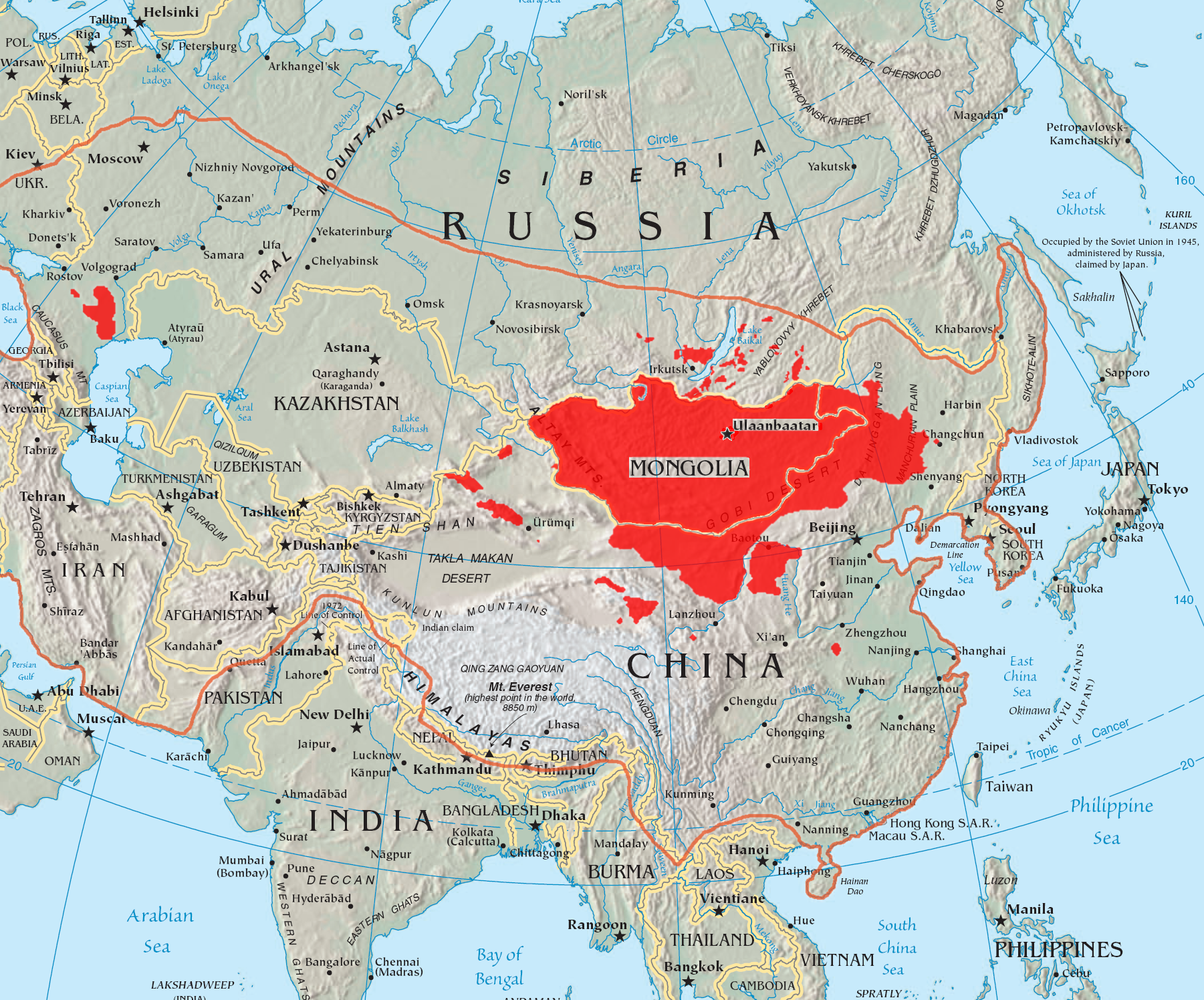
English: A map of the places that Mongol peoples live.
The orange line shows the extent of the Mongol Empire in the late 13th century. The red areas are the places dominated by ethnic Mongols. |
| Ngit-khì | |
| Lòi-ngièn |
|
| Chok-chá | Quadell |

|
本圖片是以PNG、GIF或JPEG格式上傳。然而,其中包含的資料或訊息,應該重新建立成可縮放向量圖形(SVG)檔案,以更有效率或更準確的方式儲存。如有可能,請上傳本圖片的SVG格式版本。在上傳之後,請修改維基各姊妹計畫中所有使用舊版圖片的條目(列在圖像連結章節中),替換為新版圖片,並在舊圖片的描述頁中加入{{Vector version available|新圖片名稱.svg}}模板,同時移除本模板。
|
Su-khièn
我,本作品的著作權持有者,決定用以下授權條款發佈本作品:

|
已授權您依據自由軟體基金會發行的無固定段落、封面文字和封底文字GNU自由文件授權條款1.2版或任意後續版本,對本檔進行複製、傳播和/或修改。該協議的副本列在GNU自由文件授權條款中。 |
| 此檔案採用創用CC 姓名標示-相同方式分享 3.0 未在地化版本授權條款。 | ||
| ||
| 已新增授權條款標題至此檔案,作為GFDL授權更新的一部份。 |
此檔案採用創用CC 姓名標示-相同方式分享 2.0 通用版授權條款。
- Ngì cho-tet chhṳ-yù:
- fûn-hióng – fu̍k-chṳ, fat-pu lâu chhòn-pô pún chok-phín
- chhùng-sîn siû-kói – chhóng-chok yên-yi̍t chok-phín
- 惟需遵照下列條件:
- 姓名標示 – 您必須指名出正確的製作者,和提供授權條款的連結,以及表示是否有對內容上做出變更。您可以用任何合理的方式來行動,但不得以任何方式表明授權條款是對您許可或是由您所使用。
- siông-thùng fông-sṳt fûn-hióng – 如果您利用本素材進行再混合、轉換或創作,您必須基於如同原先的相同或兼容的條款,來分布您的貢獻成品。
Ngì cho-tet sién-chet Ngì sî-yeu ke su-khièn thiàu-khóan.
Vùn-khien li̍t-sṳ́
Tiám-khim ngit-khì / sṳ̀-kiên lòi chhà-khon tông-sṳ̀ chhut-hien-ko ke vùn-khien.
| Ngit khì / Sṳ̀-kiên | Suk-lio̍k-thù | Vì-thu | Yung-fu | Yi-kien | |
|---|---|---|---|---|---|
| tông-chhièn | 2023年5月29日 (Yit) 14:37 | | 1,801 × 1,495(2.79 MB) | Artanisen | High resolution map with the same borders and areas as version 17:34, 16 July 2005 (UTC) |
| 2021年4月10日 (Liuk) 20:13 |  | 728 × 525(279 KB) | Fæ | Reverted to version as of 17:34, 16 July 2005 (UTC) Untrusted work of sockpuppets | |
| 2019年1月17日 (Si) 03:35 |  | 728 × 525(295 KB) | Anchuhu | mongol | |
| 2017年6月22日 (Si) 10:56 |  | 728 × 525(630 KB) | 일성강 | Reverted to version as of 12:47, 1 June 2017 (UTC) | |
| 2017年6月17日 (Liuk) 08:54 |  | 728 × 525(279 KB) | Calthinus | Reverted to version as of 17:34, 16 July 2005 (UTC) | |
| 2017年6月1日 (Si) 12:47 |  | 728 × 525(630 KB) | 일성강 | fixed | |
| 2005年7月16日 (Liuk) 17:34 |  | 728 × 525(279 KB) | Hottentot~commonswiki | This is a map of the places that Mongol peoples live. The information is based off of w:en:Image:Mongolsethnic.jpg, and the map I started with is w:en:Image:Asia-map.png. The orange line shows the extent of the Mongol Empire in the late 13th c | |
| 2005年7月16日 (Liuk) 13:14 |  | 728 × 525(297 KB) | Quadell | This is a map of the places that Mongol peoples live. The information is based off of [:w:en:Image:Mongolsethnic.jpg]], and the map I started with is w:en:Image:Asia-map.png. The orange line shows the extent of the Mongol Empire in the late 13th ce |
Vùn-khien yung-chhú
Hâ poi ke 1-chak ya̍p-mien lièn-chiap to pún vùn-khien:
Chhiòn-vet tóng-on sṳ́-yung chhong-khóng
Hâ-lie̍t khì-thâ Wiki chûng sṳ́-yung liá-chak tóng on:
- af.wikipedia.org ke sṳ́-yung chhong-khóng
- an.wikipedia.org ke sṳ́-yung chhong-khóng
- ar.wikipedia.org ke sṳ́-yung chhong-khóng
- arz.wikipedia.org ke sṳ́-yung chhong-khóng
- ast.wikipedia.org ke sṳ́-yung chhong-khóng
- azb.wikipedia.org ke sṳ́-yung chhong-khóng
- ba.wikipedia.org ke sṳ́-yung chhong-khóng
- be-tarask.wikipedia.org ke sṳ́-yung chhong-khóng
- be.wikipedia.org ke sṳ́-yung chhong-khóng
- bg.wiktionary.org ke sṳ́-yung chhong-khóng
- bh.wikipedia.org ke sṳ́-yung chhong-khóng
- br.wikipedia.org ke sṳ́-yung chhong-khóng
- bs.wikipedia.org ke sṳ́-yung chhong-khóng
- ca.wikipedia.org ke sṳ́-yung chhong-khóng
- ckb.wikipedia.org ke sṳ́-yung chhong-khóng
- cs.wikipedia.org ke sṳ́-yung chhong-khóng
- cv.wikipedia.org ke sṳ́-yung chhong-khóng
- da.wikipedia.org ke sṳ́-yung chhong-khóng
- diq.wikipedia.org ke sṳ́-yung chhong-khóng
- dsb.wikipedia.org ke sṳ́-yung chhong-khóng
- el.wikipedia.org ke sṳ́-yung chhong-khóng
- en.wikipedia.org ke sṳ́-yung chhong-khóng
Kiám-sṳ liá vùn-khien ke kiên-tô chhiòn-vet sṳ́-yung chhong-khóng.