
檔案:Vietnam relief location map.jpg

Yi-lám thai séu: 306 × 599 chhiong-su. Khì-thâ kié-sak-thu: 122 × 240 chhiong-su | 245 × 480 chhiong-su | 392 × 768 chhiong-su | 1,200 × 2,349 chhiong-su.
Ngièn-pún tóng-on (1,200 × 2,349 chhiong-su, vùn-khien thai-séu: 1.68 MB, MIME lui-hîn: image/jpeg)
Vùn-khien sot-mìn
| Mèu-sut |
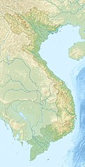
English: Location map of Vietnam.
Equirectangular projection. Strechted by 104.0%. Geographic limits of the map: * N: 24.0° N * S: 8.0° N * W: 101.8° E * E: 110.3° EMade with Natural Earth. Free vector and raster map data @ naturalearthdata.com. |
| Ngit-khì | |
| Lòi-ngièn | Chhṳ-kâ ke chok-phín |
| Chok-chá | Uwe Dedering |
| 其他版本 |
Derivative works of this file:
|

Su-khièn
我,本作品的著作權持有者,決定用以下授權條款發佈本作品:
此檔案採用創用CC 姓名標示-相同方式分享 3.0 未在地化版本授權條款。
- Ngì cho-tet chhṳ-yù:
- fûn-hióng – fu̍k-chṳ, fat-pu lâu chhòn-pô pún chok-phín
- chhùng-sîn siû-kói – chhóng-chok yên-yi̍t chok-phín
- 惟需遵照下列條件:
- 姓名標示 – 您必須指名出正確的製作者,和提供授權條款的連結,以及表示是否有對內容上做出變更。您可以用任何合理的方式來行動,但不得以任何方式表明授權條款是對您許可或是由您所使用。
- siông-thùng fông-sṳt fûn-hióng – 如果您利用本素材進行再混合、轉換或創作,您必須基於如同原先的相同或兼容的條款,來分布您的貢獻成品。

|
已授權您依據自由軟體基金會發行的無固定段落、封面文字和封底文字GNU自由文件授權條款1.2版或任意後續版本,對本檔進行複製、傳播和/或修改。該協議的副本列在GNU自由文件授權條款中。 |
Ngì cho-tet sién-chet Ngì sî-yeu ke su-khièn thiàu-khóan.
Vùn-khien li̍t-sṳ́
Tiám-khim ngit-khì / sṳ̀-kiên lòi chhà-khon tông-sṳ̀ chhut-hien-ko ke vùn-khien.
| Ngit khì / Sṳ̀-kiên | Suk-lio̍k-thù | Vì-thu | Yung-fu | Yi-kien | |
|---|---|---|---|---|---|
| tông-chhièn | 2010年4月24日 (Liuk) 10:30 | | 1,200 × 2,349(1.68 MB) | Uwe Dedering | {{Information |Description={{en|1=Location map of Vietnam. Equirectangular projection. Strechted by 104.0%. Geographic limits of the map: * N: 24.0° N * S: 8.0° N * W: 101.8° E * E: 110.3° E Made with Natural Earth. Free vector and raster map da |
Vùn-khien yung-chhú
Mò ya̍p-mien lièn-chiap to pún vùn-khien.
Chhiòn-vet tóng-on sṳ́-yung chhong-khóng
Hâ-lie̍t khì-thâ Wiki chûng sṳ́-yung liá-chak tóng on:
- als.wikipedia.org ke sṳ́-yung chhong-khóng
- am.wikipedia.org ke sṳ́-yung chhong-khóng
- ar.wikipedia.org ke sṳ́-yung chhong-khóng
- ast.wikipedia.org ke sṳ́-yung chhong-khóng
- az.wikipedia.org ke sṳ́-yung chhong-khóng
- ban.wikipedia.org ke sṳ́-yung chhong-khóng
- ba.wikipedia.org ke sṳ́-yung chhong-khóng
- bcl.wikipedia.org ke sṳ́-yung chhong-khóng
- be.wikipedia.org ke sṳ́-yung chhong-khóng
- bg.wikipedia.org ke sṳ́-yung chhong-khóng
Kiám-sṳ liá vùn-khien ke kiên-tô chhiòn-vet sṳ́-yung chhong-khóng.