
檔案:Dadao map 1939.svg

此 SVG 檔案的 PNG 預覽的大小:634 × 387 chhiong-su。 Khì-thâ kié-sak-thu: 320 × 195 chhiong-su | 640 × 391 chhiong-su | 1,024 × 625 chhiong-su | 1,280 × 781 chhiong-su | 2,560 × 1,563 chhiong-su.
Ngièn-pún tóng-on (SVG文件,尺寸:634×387像素,文件大細:2.17 MB)


|
這張圖片需要更新,因為:Saipan was part of the Japanese Empire in 1939 and not part of the USA yet.在這樣做的時候,您可以為該圖片加入時間戳。
|
Vùn-khien sot-mìn
| Mèu-sut |
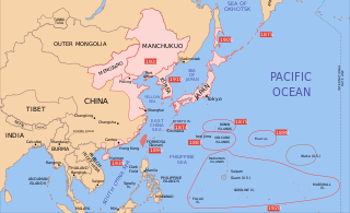
English: A map of Taiwan, 1939-09-01. Dates shown indicate the approximate year that the various powers gain control of their possessions. Japanese control of territory in China was tenuous. |
| Ngit-khì | |
| Lòi-ngièn | modification of File:Mengjiang map 1939.svg |
| Chok-chá | Bamse |
| 其他版本 |
=
|


Su-khièn
Bamse,此作品的版權所有人,決定用以下授權條款發佈本作品:

|
已授權您依據自由軟體基金會發行的無固定段落、封面文字和封底文字GNU自由文件授權條款1.2版或任意後續版本,對本檔進行複製、傳播和/或修改。該協議的副本列在GNU自由文件授權條款中。 |
此檔案採用創用CC 姓名標示-相同方式分享 3.0 未在地化版本授權條款。
姓名標示: Bamse
- Ngì cho-tet chhṳ-yù:
- fûn-hióng – fu̍k-chṳ, fat-pu lâu chhòn-pô pún chok-phín
- chhùng-sîn siû-kói – chhóng-chok yên-yi̍t chok-phín
- 惟需遵照下列條件:
- 姓名標示 – 您必須指名出正確的製作者,和提供授權條款的連結,以及表示是否有對內容上做出變更。您可以用任何合理的方式來行動,但不得以任何方式表明授權條款是對您許可或是由您所使用。
- siông-thùng fông-sṳt fûn-hióng – 如果您利用本素材進行再混合、轉換或創作,您必須基於如同原先的相同或兼容的條款,來分布您的貢獻成品。
Ngì cho-tet sién-chet Ngì sî-yeu ke su-khièn thiàu-khóan.
原始上傳日誌
| date/time | username | resolution | size | edit summary |
|---|---|---|---|---|
| 2008-12-16T15:55:54Z | User:Bamse | 634×387 | 2.15Gb | |
| 2008-12-16T15:31:45Z | User:Lokal Profil | 634×387 | 2.21Gb | Made changes from [[:Image:Mengjiang map 1939.svg]] in text editor so as to avoid font issues. |
| 2008-12-16T11:08:28Z | User:Bamse | 634×387 | 2.21Gb | {{Information |Description={{en|1=Taiwan}} |Source=modification of [[:File:Mengjiang map 1939.svg]] |Author=[[User:Bamse|Bamse]] |Date=16/12/2008 |Permission= |other_versions= }} |
| 註解 | 該圖片含有註解:在維基媒體共享資源上查看註解 |
Vùn-khien li̍t-sṳ́
Tiám-khim ngit-khì / sṳ̀-kiên lòi chhà-khon tông-sṳ̀ chhut-hien-ko ke vùn-khien.
| Ngit khì / Sṳ̀-kiên | Suk-lio̍k-thù | Vì-thu | Yung-fu | Yi-kien | |
|---|---|---|---|---|---|
| tông-chhièn | 2023年9月16日 (Liuk) 14:45 | | 634 × 387(2.17 MB) | KajenCAT | File uploaded using svgtranslate tool (https://svgtranslate.toolforge.org/). Added translation for ca. |
| 2021年6月13日 (Ngit) 20:02 |  | 634 × 387(2.15 MB) | Bamse | Made Saipan (and Rota Island) Japanese | |
| 2010年8月27日 (Ńg) 01:34 |  | 634 × 387(2.15 MB) | Splittist | No reason for Xinjiang to have separate borders from China | |
| 2009年7月1日 (Sâm) 02:56 |  | 634 × 387(2.15 MB) | BetacommandBot | move approved by: User:Enomil This image was moved from File:Taiwan - Japan.svg == Summary == {{Information |Description={{en|1=A map of Taiwan, 1939-09-01. Dates shown indicate the approximate year that the various powers gain control of their |
Vùn-khien yung-chhú
Hâ poi ke 1-chak ya̍p-mien lièn-chiap to pún vùn-khien:
Chhiòn-vet tóng-on sṳ́-yung chhong-khóng
Hâ-lie̍t khì-thâ Wiki chûng sṳ́-yung liá-chak tóng on:
- ast.wikipedia.org ke sṳ́-yung chhong-khóng
- azb.wikipedia.org ke sṳ́-yung chhong-khóng
- be.wikipedia.org ke sṳ́-yung chhong-khóng
- bg.wikipedia.org ke sṳ́-yung chhong-khóng
- ca.wikipedia.org ke sṳ́-yung chhong-khóng
- en.wikipedia.org ke sṳ́-yung chhong-khóng
- it.wikipedia.org ke sṳ́-yung chhong-khóng
- mk.wikipedia.org ke sṳ́-yung chhong-khóng
- ml.wikipedia.org ke sṳ́-yung chhong-khóng
- pt.wikipedia.org ke sṳ́-yung chhong-khóng
- uk.wikipedia.org ke sṳ́-yung chhong-khóng
- vi.wikipedia.org ke sṳ́-yung chhong-khóng
- www.wikidata.org ke sṳ́-yung chhong-khóng