
檔案:The British Empire1.png

Yi-lám thai séu: 800 × 406 chhiong-su. Khì-thâ kié-sak-thu: 320 × 162 chhiong-su | 640 × 325 chhiong-su | 1,024 × 520 chhiong-su | 1,280 × 650 chhiong-su | 2,754 × 1,398 chhiong-su.
Ngièn-pún tóng-on (2,754 × 1,398 chhiong-su, vùn-khien thai-séu: 145 KB, MIME lui-hîn: image/png)
Vùn-khien sot-mìn
| Mèu-sut |
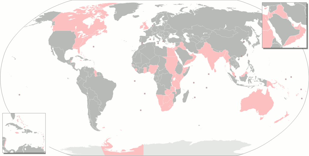
Deutsch: Gebiete, die zur einen oder anderen Zeit Teil des britischen Weltreiches waren.
English: The territories that were at one time or another part of the British Empire.
Français : Territoires ayant fait partie de l'Empire britanique.
Русский: Территории, когда-либо бывшие частью Британской империи.
Українська: Території, які колись були частиною Британської імперії. |
| Ngit-khì | |
| Lòi-ngièn | Chhṳ-kâ ke chok-phín |
| Chok-chá | Gd21091993 |
| 其他版本 |
The British Empire.png The British Empire (including Crown Dependencies, Crown Colonies-Overseas Territories, Protectorates, Military Administrations).png Map of British India.png British Empire Map (Chinese).svg The British Empire Anachronous.png forked on enwiki |
.png)
.svg)
Su-khièn
| 我,此作品的版權所有人,釋出此作品至公共領域。此授權條款在全世界均適用。 這可能在某些國家不合法,如果是的話: 我授予任何人有權利使用此作品於任何用途,除受法律約束外,不受任何限制。 |
Vùn-khien li̍t-sṳ́
Tiám-khim ngit-khì / sṳ̀-kiên lòi chhà-khon tông-sṳ̀ chhut-hien-ko ke vùn-khien.
| Ngit khì / Sṳ̀-kiên | Suk-lio̍k-thù | Vì-thu | Yung-fu | Yi-kien | |
|---|---|---|---|---|---|
| tông-chhièn | 2021年11月7日 (Ngit) 23:48 | | 2,754 × 1,398(145 KB) | Randomastwritter | somali galbeed |
| 2021年10月31日 (Ngit) 00:51 |  | 2,754 × 1,398(144 KB) | Randomastwritter | juba | |
| 2021年10月31日 (Ngit) 00:49 |  | 2,754 × 1,400(526 KB) | Randomastwritter | jubaland | |
| 2018年2月3日 (Liuk) 23:20 |  | 2,754 × 1,398(144 KB) | Maphobbyist | Upload | |
| 2018年1月27日 (Liuk) 10:42 |  | 2,754 × 1,398(144 KB) | Maphobbyist | Added Weihei, Heligoland, the Mosquito Coast, Afghanistan which were under some form of British rule. Colored Chatham Islands of New Zealand and the southeastern islands of Papua New Guinea in pink. | |
| 2013年2月16日 (Liuk) 07:45 |  | 2,753 × 1,400(65 KB) | JohnnyMrNinja | remove unused alpha, indexed colors and increased compression | |
| 2010年5月2日 (Ngit) 19:50 |  | 2,753 × 1,400(477 KB) | Gd21091993 | {{Information |Description={{fr|1=Toute les possessions qui on un jour fait partie de l'empire britanique}} |Source={{own}} |Author=Gd21091993 |Date=02/05/2010 |Permission= |other_versions= }} |
Vùn-khien yung-chhú
Hâ poi ke 1-chak ya̍p-mien lièn-chiap to pún vùn-khien:
Chhiòn-vet tóng-on sṳ́-yung chhong-khóng
Hâ-lie̍t khì-thâ Wiki chûng sṳ́-yung liá-chak tóng on:
- an.wikipedia.org ke sṳ́-yung chhong-khóng
- br.wikipedia.org ke sṳ́-yung chhong-khóng
- bs.wikipedia.org ke sṳ́-yung chhong-khóng
- da.wikipedia.org ke sṳ́-yung chhong-khóng
- eo.wikipedia.org ke sṳ́-yung chhong-khóng
- es.wikipedia.org ke sṳ́-yung chhong-khóng
- eu.wikipedia.org ke sṳ́-yung chhong-khóng
- fa.wikipedia.org ke sṳ́-yung chhong-khóng
- fr.wikipedia.org ke sṳ́-yung chhong-khóng
- gl.wikipedia.org ke sṳ́-yung chhong-khóng
- hif.wikipedia.org ke sṳ́-yung chhong-khóng
- hr.wikipedia.org ke sṳ́-yung chhong-khóng
- hu.wikipedia.org ke sṳ́-yung chhong-khóng
- hu.wiktionary.org ke sṳ́-yung chhong-khóng
- is.wikipedia.org ke sṳ́-yung chhong-khóng
- it.wikipedia.org ke sṳ́-yung chhong-khóng
- ne.wikipedia.org ke sṳ́-yung chhong-khóng
- nl.wikipedia.org ke sṳ́-yung chhong-khóng
- ro.wikipedia.org ke sṳ́-yung chhong-khóng
- ru.wiktionary.org ke sṳ́-yung chhong-khóng
- sah.wikipedia.org ke sṳ́-yung chhong-khóng
- sh.wikipedia.org ke sṳ́-yung chhong-khóng
- xh.wikipedia.org ke sṳ́-yung chhong-khóng