
檔案:Europe-Isle of Man.svg

此 SVG 檔案的 PNG 預覽的大小:713 × 600 chhiong-su。 Khì-thâ kié-sak-thu: 285 × 240 chhiong-su | 571 × 480 chhiong-su | 913 × 768 chhiong-su | 1,218 × 1,024 chhiong-su | 2,435 × 2,048 chhiong-su | 2,045 × 1,720 chhiong-su.
Ngièn-pún tóng-on (SVG文件,尺寸:2,045×1,720像素,文件大細:2.24 MB)
Vùn-khien sot-mìn
| Mèu-sut |
English:
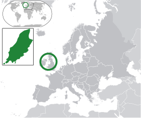
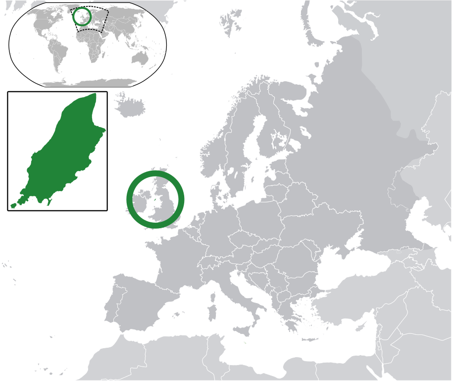
Map in English of the Isle of Man, with bounds of sheadings, towns, villages, districts and parishes. (Green) Isle of Man.
(Gray) Europe.
(Light-gray) The surrounding region.
The Full Map of the Isle of Man |
||
| Ngit-khì | |||
| Lòi-ngièn | 我個人以下列物件為基礎來創作: IsleOfMan SheadingsAndParishes-en.svg | ||
| Chok-chá | Chipmunkdavis | ||
| Khièn-han: (Chhùng-yung liá-chak tóng-on) |
此檔案採用創用CC 姓名標示-相同方式分享 3.0 未在地化版本授權條款。
|
||
| SVG開發 |
|
原始上傳日誌
This image is a derivative work of the following images:
- licensed with Cc-by-sa-3.0
- 2011-02-21T07:49:57Z Chipmunkdavis 2045x1720 (2394864 Bytes)
- IsleOfMan SheadingsAndParishes-en.svg licensed with Cc-by-sa-3.0,2.5,2.0,1.0, GFDL
- 2008-01-17T12:48:28Z Sémhur 1200x1100 (227618 Bytes) Update
- 2007-05-29T20:36:04Z Sémhur 0x0 (364350 Bytes) {{Information |Description=Map in English of the [[:en:Isle of Man|Isle of Man]], with bounds of sheadings, towns, villages, districts and parishes. |Source=Own work. Based on maps [[:Image:Isle of Man map-fr.svg]], [[:Image:
Uploaded with derivativeFX
Vùn-khien li̍t-sṳ́
Tiám-khim ngit-khì / sṳ̀-kiên lòi chhà-khon tông-sṳ̀ chhut-hien-ko ke vùn-khien.
| Ngit khì / Sṳ̀-kiên | Suk-lio̍k-thù | Vì-thu | Yung-fu | Yi-kien | |
|---|---|---|---|---|---|
| tông-chhièn | 2011年3月2日 (Sâm) 06:10 | | 2,045 × 1,720(2.24 MB) | Chipmunkdavis | Redid inset |
| 2011年3月2日 (Sâm) 06:03 |  | 2,045 × 1,720(2.22 MB) | Chipmunkdavis | Without inset | |
| 2011年3月2日 (Sâm) 06:01 |  | 2,045 × 1,720(2.22 MB) | Chipmunkdavis | One more try | |
| 2011年2月21日 (Yit) 09:03 |  | 2,045 × 1,720(2.22 MB) | Chipmunkdavis | Grouped inset | |
| 2011年2月21日 (Yit) 09:00 |  | 2,045 × 1,720(2.22 MB) | Chipmunkdavis | File not appearing properly, reuploading | |
| 2011年2月21日 (Yit) 08:06 |  | 2,045 × 1,720(2.22 MB) | Chipmunkdavis | {{Information |Description={{en|1={{Europe-SVG-en|Northern Cyprus}}}} {{en|1=The Full Map of Jersey}} Map in english of the Isle of Man, with bounds of sheadings, towns, villages, districts and parishes. |Source=*[[:File:Europe-Jersey. |
Vùn-khien yung-chhú
Hâ poi ke 1-chak ya̍p-mien lièn-chiap to pún vùn-khien:
Chhiòn-vet tóng-on sṳ́-yung chhong-khóng
Hâ-lie̍t khì-thâ Wiki chûng sṳ́-yung liá-chak tóng on:
- ace.wikipedia.org ke sṳ́-yung chhong-khóng
- an.wikipedia.org ke sṳ́-yung chhong-khóng
- ar.wikipedia.org ke sṳ́-yung chhong-khóng
- arz.wikipedia.org ke sṳ́-yung chhong-khóng
- ast.wikipedia.org ke sṳ́-yung chhong-khóng
- az.wikipedia.org ke sṳ́-yung chhong-khóng
- ba.wikipedia.org ke sṳ́-yung chhong-khóng
- bg.wikipedia.org ke sṳ́-yung chhong-khóng
- bh.wikipedia.org ke sṳ́-yung chhong-khóng
- bn.wikipedia.org ke sṳ́-yung chhong-khóng
- ca.wikipedia.org ke sṳ́-yung chhong-khóng
- cdo.wikipedia.org ke sṳ́-yung chhong-khóng
- cs.wikipedia.org ke sṳ́-yung chhong-khóng
- diq.wikipedia.org ke sṳ́-yung chhong-khóng
- en.wikipedia.org ke sṳ́-yung chhong-khóng
- eo.wikipedia.org ke sṳ́-yung chhong-khóng
- es.wikipedia.org ke sṳ́-yung chhong-khóng
- ext.wikipedia.org ke sṳ́-yung chhong-khóng
- fi.wiktionary.org ke sṳ́-yung chhong-khóng
- fr.wikipedia.org ke sṳ́-yung chhong-khóng
- ga.wikipedia.org ke sṳ́-yung chhong-khóng
- gl.wikipedia.org ke sṳ́-yung chhong-khóng
- ha.wikipedia.org ke sṳ́-yung chhong-khóng
- he.wikipedia.org ke sṳ́-yung chhong-khóng
- ia.wikipedia.org ke sṳ́-yung chhong-khóng
- incubator.wikimedia.org ke sṳ́-yung chhong-khóng
- it.wikipedia.org ke sṳ́-yung chhong-khóng
- ja.wikipedia.org ke sṳ́-yung chhong-khóng
- kab.wikipedia.org ke sṳ́-yung chhong-khóng
- kk.wikipedia.org ke sṳ́-yung chhong-khóng
- km.wikipedia.org ke sṳ́-yung chhong-khóng
- la.wikipedia.org ke sṳ́-yung chhong-khóng
- lb.wikipedia.org ke sṳ́-yung chhong-khóng
- lij.wikipedia.org ke sṳ́-yung chhong-khóng
- lv.wikipedia.org ke sṳ́-yung chhong-khóng
- mk.wikipedia.org ke sṳ́-yung chhong-khóng
- my.wikipedia.org ke sṳ́-yung chhong-khóng
Kiám-sṳ liá vùn-khien ke kiên-tô chhiòn-vet sṳ́-yung chhong-khóng.