
檔案:Red Sea topographic map-en.jpg

Yi-lám thai séu: 367 × 600 chhiong-su. Khì-thâ kié-sak-thu: 147 × 240 chhiong-su | 293 × 480 chhiong-su | 470 × 768 chhiong-su | 626 × 1,024 chhiong-su | 1,655 × 2,705 chhiong-su.
Ngièn-pún tóng-on (1,655 × 2,705 chhiong-su, vùn-khien thai-séu: 1.63 MB, MIME lui-hîn: image/jpeg)
Vùn-khien sot-mìn
| 拍攝地點 | | 位於此地的本圖片與其他圖片: OpenStreetMap |
|---|
| Mèu-sut |
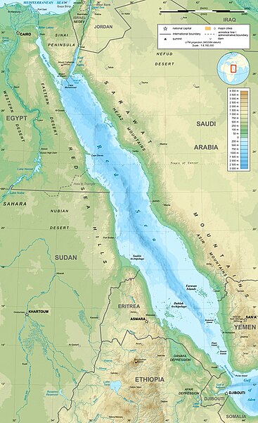
English: Topographic map in English of the Red Sea, UTM projection (WGS84 datum).
Note : for translation purpose, use the SVG version. Français : Carte topographique en anglais de la Mer Rouge, projection UTM (WGS84 datum).
|
||
| Ngit-khì | |||
| Lòi-ngièn | Own work (see complete description on Image:Red_Sea_topographic_map-en.svg) | ||
| Chok-chá | Eric Gaba (Sting - fr:Sting) | ||
| Khièn-han: (Chhùng-yung liá-chak tóng-on) |
|
||
| 其他版本 |
[]
|


Su-khièn
我,本作品的著作權持有者,決定用以下授權條款發佈本作品:

|
已授權您依據自由軟體基金會發行的無固定段落、封面文字和封底文字GNU自由文件授權條款1.2版或任意後續版本,對本檔進行複製、傳播和/或修改。該協議的副本列在GNU自由文件授權條款中。 |
This file is licensed under the Creative Commons Attribution-Share Alike 4.0 International, 3.0 Unported, 2.5 Generic, 2.0 Generic and 1.0 Generic license.
- Ngì cho-tet chhṳ-yù:
- fûn-hióng – fu̍k-chṳ, fat-pu lâu chhòn-pô pún chok-phín
- chhùng-sîn siû-kói – chhóng-chok yên-yi̍t chok-phín
- 惟需遵照下列條件:
- 姓名標示 – 您必須指名出正確的製作者,和提供授權條款的連結,以及表示是否有對內容上做出變更。您可以用任何合理的方式來行動,但不得以任何方式表明授權條款是對您許可或是由您所使用。
- siông-thùng fông-sṳt fûn-hióng – 如果您利用本素材進行再混合、轉換或創作,您必須基於如同原先的相同或兼容的條款,來分布您的貢獻成品。
Ngì cho-tet sién-chet Ngì sî-yeu ke su-khièn thiàu-khóan.
Vùn-khien li̍t-sṳ́
Tiám-khim ngit-khì / sṳ̀-kiên lòi chhà-khon tông-sṳ̀ chhut-hien-ko ke vùn-khien.
| Ngit khì / Sṳ̀-kiên | Suk-lio̍k-thù | Vì-thu | Yung-fu | Yi-kien | |
|---|---|---|---|---|---|
| tông-chhièn | 2023年12月29日 (Ńg) 15:40 | | 1,655 × 2,705(1.63 MB) | Sting | Without frame |
| 2010年7月19日 (Yit) 13:37 |  | 1,655 × 2,705(1.68 MB) | Sting | Color profile | |
| 2008年9月2日 (Ngi) 04:47 |  | 1,655 × 2,705(1.6 MB) | Sting | New standard colors ; bathymetry from ETOPO1 ; etc. | |
| 2008年4月3日 (Si) 19:35 |  | 1,655 × 2,705(1.67 MB) | Sting | Additional corrections | |
| 2008年4月3日 (Si) 13:09 |  | 1,655 × 2,705(1.71 MB) | Sting | Some names corrections ; some improvements | |
| 2008年4月3日 (Si) 11:26 |  | 1,655 × 2,705(1.67 MB) | Sting | Little correction | |
| 2008年4月2日 (Sâm) 22:32 |  | 1,655 × 2,705(1.7 MB) | Sting | {{Location|21|00|00|N|38|00|00|E|scale:10000000}} <br/> {{Information |Description={{en|Topographic map in English of the red Sea<br/>''Note :'' for translation purpose, use the SVG version.}} {{fr |
Vùn-khien yung-chhú
Hâ poi ke 1-chak ya̍p-mien lièn-chiap to pún vùn-khien:
Chhiòn-vet tóng-on sṳ́-yung chhong-khóng
Hâ-lie̍t khì-thâ Wiki chûng sṳ́-yung liá-chak tóng on:
- ami.wikipedia.org ke sṳ́-yung chhong-khóng
- am.wikipedia.org ke sṳ́-yung chhong-khóng
- ban.wikipedia.org ke sṳ́-yung chhong-khóng
- bg.wikipedia.org ke sṳ́-yung chhong-khóng
- bh.wikipedia.org ke sṳ́-yung chhong-khóng
- bn.wikipedia.org ke sṳ́-yung chhong-khóng
- ca.wikipedia.org ke sṳ́-yung chhong-khóng
- ckb.wikipedia.org ke sṳ́-yung chhong-khóng
- en.wikipedia.org ke sṳ́-yung chhong-khóng
- eu.wikipedia.org ke sṳ́-yung chhong-khóng
- fa.wikipedia.org ke sṳ́-yung chhong-khóng
- fa.wikivoyage.org ke sṳ́-yung chhong-khóng
- gu.wikipedia.org ke sṳ́-yung chhong-khóng
- he.wikipedia.org ke sṳ́-yung chhong-khóng
- he.wiktionary.org ke sṳ́-yung chhong-khóng
- hi.wikipedia.org ke sṳ́-yung chhong-khóng
- hr.wikipedia.org ke sṳ́-yung chhong-khóng
- ilo.wikipedia.org ke sṳ́-yung chhong-khóng
- incubator.wikimedia.org ke sṳ́-yung chhong-khóng
- ja.wikipedia.org ke sṳ́-yung chhong-khóng
- ja.wikibooks.org ke sṳ́-yung chhong-khóng
- ka.wikipedia.org ke sṳ́-yung chhong-khóng
- kcg.wikipedia.org ke sṳ́-yung chhong-khóng
- kn.wikipedia.org ke sṳ́-yung chhong-khóng
- ko.wikipedia.org ke sṳ́-yung chhong-khóng
- lfn.wikipedia.org ke sṳ́-yung chhong-khóng
- lv.wikipedia.org ke sṳ́-yung chhong-khóng
- mai.wikipedia.org ke sṳ́-yung chhong-khóng
- ml.wikipedia.org ke sṳ́-yung chhong-khóng
- ms.wikipedia.org ke sṳ́-yung chhong-khóng
- my.wikipedia.org ke sṳ́-yung chhong-khóng
- ne.wikipedia.org ke sṳ́-yung chhong-khóng
- no.wikipedia.org ke sṳ́-yung chhong-khóng
- olo.wikipedia.org ke sṳ́-yung chhong-khóng
- pl.wikipedia.org ke sṳ́-yung chhong-khóng
Kiám-sṳ liá vùn-khien ke kiên-tô chhiòn-vet sṳ́-yung chhong-khóng.