
檔案:Klimagürtel-der-erde-gemäßigte-zone.png

Yi-lám thai séu: 800 × 400 chhiong-su. Khì-thâ kié-sak-thu: 320 × 160 chhiong-su | 640 × 320 chhiong-su | 1,024 × 512 chhiong-su | 1,280 × 640 chhiong-su | 3,600 × 1,800 chhiong-su.
Ngièn-pún tóng-on (3,600 × 1,800 chhiong-su, vùn-khien thai-séu: 726 KB, MIME lui-hîn: image/png)
Vùn-khien sot-mìn
| Mèu-sut |
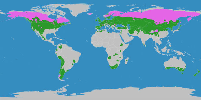
English: This map shows the Earth zones with a temperate climate.
Cold temperate (boreal) climate
Warm temperate climate
Deutsch: Diese Karte stellt die gemäßigte Klimazone der Erde dar.
Kaltgemäßigtes (boreales) Klima
Warmgemäßigtes Klima |
| Ngit-khì | |
| Lòi-ngièn |
English: Own work on the basis of the following data: Deutsch: Selbst erstellt auf Basis dieser Geodaten:
|
| Chok-chá | LordToran |
| Khièn-han: (Chhùng-yung liá-chak tóng-on) |
|
| 其他版本 |
 |
Su-khièn
此檔案採用創用CC 姓名標示-相同方式分享 3.0 未在地化版本授權條款。
- Ngì cho-tet chhṳ-yù:
- fûn-hióng – fu̍k-chṳ, fat-pu lâu chhòn-pô pún chok-phín
- chhùng-sîn siû-kói – chhóng-chok yên-yi̍t chok-phín
- 惟需遵照下列條件:
- 姓名標示 – 您必須指名出正確的製作者,和提供授權條款的連結,以及表示是否有對內容上做出變更。您可以用任何合理的方式來行動,但不得以任何方式表明授權條款是對您許可或是由您所使用。
- siông-thùng fông-sṳt fûn-hióng – 如果您利用本素材進行再混合、轉換或創作,您必須基於如同原先的相同或兼容的條款,來分布您的貢獻成品。
Vùn-khien li̍t-sṳ́
Tiám-khim ngit-khì / sṳ̀-kiên lòi chhà-khon tông-sṳ̀ chhut-hien-ko ke vùn-khien.
| Ngit khì / Sṳ̀-kiên | Suk-lio̍k-thù | Vì-thu | Yung-fu | Yi-kien | |
|---|---|---|---|---|---|
| tông-chhièn | 2016年10月11日 (Ngi) 21:06 | | 3,600 × 1,800(726 KB) | Maphobbyist | The Caspian Sea was omitted. The Köppen system is based on the concept that climate types are correlated with the natural vegetation. |
| 2007年10月15日 (Yit) 15:15 |  | 3,600 × 1,800(626 KB) | Lortordermur | ||
| 2007年6月5日 (Ngi) 20:43 |  | 3,445 × 1,731(664 KB) | Lortordermur | == Beschreibung == {{Information |Description=Diese Karte stellt die gemäßigte Klimazone der Erde dar. {{legend|#e465e6|Kaltgemäßigtes (boreales) Klima}} {{legend|#2a982a|Warmgemäßigtes Klima}} |Source=Selbst erstellt auf Basis [http://www.copern |
Vùn-khien yung-chhú
Hâ poi ke 1-chak ya̍p-mien lièn-chiap to pún vùn-khien:
Chhiòn-vet tóng-on sṳ́-yung chhong-khóng
Hâ-lie̍t khì-thâ Wiki chûng sṳ́-yung liá-chak tóng on:
- el.wikipedia.org ke sṳ́-yung chhong-khóng
- hu.wikipedia.org ke sṳ́-yung chhong-khóng
- nn.wikipedia.org ke sṳ́-yung chhong-khóng
- sk.wikipedia.org ke sṳ́-yung chhong-khóng
- sw.wikipedia.org ke sṳ́-yung chhong-khóng
- vi.wikipedia.org ke sṳ́-yung chhong-khóng